|
|
2023 Silver Lake Drain Update The Silver Lake drain has been open for the last several years as the levels have remained in balance, only draining during spring thaws and higher levels. With the heat and lack of rain this summer, the water level has been at or near the established level of 862. Feet above sea level. The level has declined to below that level most of the summer. The last current reading was taken on 7-4-2023 and the level was at 861.94 feet, resulting in the level being at .72 inches below the established level and the drain is currently clear and open. The drain is monitored, cleaned on a weekly basis, in fact most of the time, more often than that by volunteer resident, Al Strange. The County Drain Commissioner, Andy Smits oversees and determines any actions required. Our SLIA drain liaison committee chair, Gary Borucki is in contact with both and also keeps records of any ongoing events needing attention as well as the current readings.
2022 Silver Lake Drain Update The Silver Lake drain has been open for the last couple of years as the levels have remained in balance, only draining during spring thaws and higher levels. With the heat and lack of rain this summer, the water level has been at or near the established level of 862. Feet above sea level. The level has declined to below that level most of the summer. The last current reading was taken on 8-25-2022 and the level was at 861.44 feet, resulting in the level being at 6.72 inches below the established level. The drain is monitored, cleaned on a weekly basis, in fact most of the time, more often than that by volunteer resident, Al Strange. The County Drain Commissioner, Andy Smits oversees and determines any actions required. Our SLIA drain liaison committee chair, Gary Borucki is in contact with both and also keeps records of any ongoing events needing attention as well as the current readings.
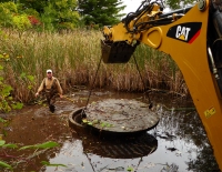
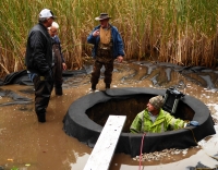
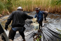
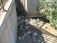
Spring 2019 Silver Lake Drain Update Last fall In October, the Drain Commissioner, Steve Largent, with the help of several Silver Lake residents began several drain maintenance functions that have not been performed in the last 30 years the drain has been in place. They started by removing the screen covering the drain which is located in the Holiday Park Campground area. The purpose was to check for any obstructions which could hamper the functionality of the drain. A camera was run through from each end of the drain line and the pipe was not clogged in any area! A filter fabric was placed around the drain and some gravel to hold it in place was laid. More gravel and a second circle of fencing around the drain to keep out debris will be installed soon. The drain empties into Cox Pond, then into Beitner Creek and on into the Boardman River. (See drawings next article) As discovered in the mandated tri-annual drain inspection, the culvert over Beitner Creek has started to erode and needs a sleeve installed to prevent its collapse. Once these items are completed , these preventative actions should keep our drain functioning for a number of years. (See pics below - first pic is before pic, then volunteers at work.)
SILVER LAKE HISTORY - SLIA/DRAIN/OTHER HISTORICAL INFORMATION
High Water Overflow Drain(This category is currently being updated)In 1987 a high water overflow drain was installed on Silver Lake by Grand Traverse county according to a petition by a majority of Silver Lake property owners to alleviate recurring seasonal high water levels resulting in flooding, shoreline erosion and destruction of greenbelt. A court order established a "high water only lake level for Silver Lake". That level to be 862 feet above mean sea level and is a maximum. No minimum lake level was requested or established because of the exhorbitant expense of pumping water back into the lake, as well as the unknown drain on the ground water tables to do so. Certain restrictions were placed on the drain discharge. The temperature of the discharge water could not exceed 68 degrees F, the combined flow of Bass Lake and Silver Lake discharge could not exceed 10 cubic feet per second and lastly the discharged water must be of good quality. To that end the County Drain Commissioner`s Office was charged to test lake water quality yearly. The Drain Commissioner is also responsible for inspecting and maintaining the drain structure. Drain Commission Office expenses for these duties are funded from a special assessment fund established at the time of construction . Additional funds to supplement the fund are assessed when the balance does not support the expenses.
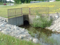
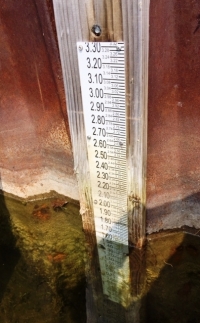
Contrary to rumors that have circulated through the years, the drain is not a dam that can be opened and closed at will to release too much water, thus lowering the lake level and conceivably harming outlet areas to the south. It is an overflow drain, much the same as your bathtub drain, a drain that allows water to drain down a pipe into another pipe to your septic system, in this case the pipe is going under the road (US-31) and exiting into Cox Pond. The top of the drain is at the determined lake water level, 862` above sea level, so the water does not exit unless it is above that level. A further curb is a valve located in the wheelhouse that opens the drain, so even when the water level is high, it does not drain unless the valve is opened. This valve can only be opened by the County Drain Commissioner, commissioned by the County to be in charge of it. (Normally the valve is opened in the fall or mid-winter and closed in the late spring.) During low water levels, the drain may not be opened or drained for several years, only to be held in reserve to be used when the cyclical high water levels occur. The lake level is determined by a gauge which is situated in the cove south of Roman Dr, see pics. ... See 2 very informative articles regarding the drain under Newsletters, Spring 2014.
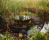
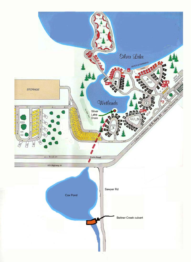
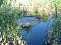
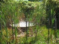
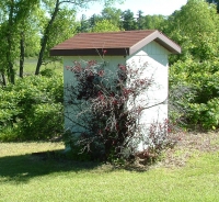
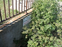
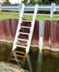
Drain is located at the South end of the lake in the Cove to the West of Holiday Park Campground. 1st Pic with sign identifying as Silver Lake Drainage System. Pics 2 & 3 looking south to drainage area during high and low water levels. Pictures of the Overflow drain. 1st Pic when water was at determined level, not overflowing. 2d Pic with water levels low and much of drain exposed. The fence was erected around the drain to keep the "critters" out. 3d Pic is the Valve House, housing On/Off valve.
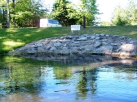
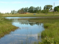
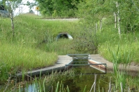
The drain travels under U.S. 31 and exits into Cox Pond, see 1st Pic. 2d and 3d Pics are of Cox pond at high and low water levels.
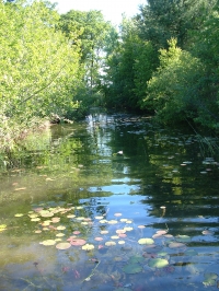
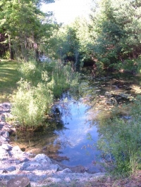
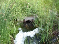
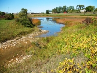
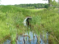
The drain exits Cox Pond at the south end (near Sawyer Road) into Beitner Creek which travels south and east to join the Boardman River. Pics 1 and 2 are of the exit strucure at high and low water levels. Pic 3 displays the sign Silver Lake Drainage system.
Beitner Creek with outlet coming from Cox Pond pictured at high land low levels.
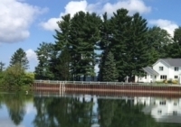
PICTURES OF THE LAKE LEVEL GAUGE FOR SILVER LAKE The gauge to determine the lake level for Silver Lake is located in Kevwitch Cove, at the north end at Roman Drive. It is fastened to the breakwall for Roman Drive. See following pics..
Silver Lake Improvement Association (SLIA) History Silver Lake Improvement Association History Information gathered from the archives show that efforts first began in 1963 to form the SLIA. It was incorporated as a non-profit Michigan corporation in 1965. The impetus for its creation was to seek a remedy to alleviate the low water levels in the mid 1960’s, especially in the south end of the lake. Then the water began to rise in the late 1960’s and early 1970’s. In 1974 they had a reverse problem from the 60’s, the water levels were so high, trees were dying on the shorelines and people were experiencing flooded septic tanks and basements. The first effort of the SLIA to address this problem was to petition the county to maintain a certain lake level. The county interpreted the petition to mean both draining lake water during high levels and pumping in ground water during low levels. An Adhoc committee of lake residents went to court at that time to stop the measure due to the negative and expensive aspects of extracting huge amounts of ground water to “maintain” the level during low times. As in the 60’s, the normal cyclical levels took over and the level went down. In the mid 80’s, the levels started to rise again. As the lake levels continued to rise, damaging both septic systems and buildings, the SLIA again went into action to address the continuing problem. There was an effort to locate a creek that allegedly was closed off during road construction of US31. There was some evidence that a creek once flowed into and out of Silver Lake, but not compelling enough to force the Department of Transportation to take responsibility. So once again they went to court, this time to establish only a high water level and to install an overflow drain to allow water to flow out when above the high water level that was set by the court. After petitions, public hearings, and court dates, the drain became a reality. Located on the South end of the lake, it flows under the highway into Beitner Creek, then into the Boardman River and ultimately into Grand Traverse Bay. Although it is often not opened for years at a time, it remains a safeguard when needed. This places a large responsibility on the residents of Silver Lake to maintain the water quality, not only for the benefit of the riparians who share and reside on the lake, but to be mindful of the effect on these downriver streams. The main focus of the SLIA continues to be to maintain the water quality through efforts to contain invasive species and to educate regarding these invasives, feeding waterfowl, containing swimmers’ itch, limiting phosphorous use. The SLIA publishes a newsletter and maintains a website to further this education, advise of current events, encourage safe lake use practices, co-operating with the townships, Blair and Garfield, state and local law enforcement agencies, Michigan DNR and related agencies in this effort. The SLIA has maintained a neutral stance on issues of preference by residents, leaving those issues to the governing bodies involved, only becoming involved when the environment and quality of the lake itself are involved. To this end, it has sponsored the treatment of invasive species that threaten the lake in cooperation with the townships and state agencies governing such treatments. Over the years the SLIA has sponsored many social events, such as fishing contests, a 4th of July Regatta, the beach ball, as well as civic involvement such as the Adopt-A-Road project, bringing the residents together as a community. ____________________________________________________________________________________________________________________________
Lake Numbers - Everything You Ever Wanted To KnowFor a Lake Map, Watershed Map & Lots of Lake Statistics Click on the following link: Fusilier's Atlas of Silver Lake Click on the link below to see USGS water level data from the 70's, 80's and 90's. Lowest level we found a record for was 858 ft above mean sea level (amsl) in 1954. Highest level was 865.23 in 1987. By comparison the lake level was about 862 in the spring of 2007. _______________________________________________________________________________________________________________________________________________
Lake History & Information RequestPeople who have lived on Silver Lake for many years have a wealth of knowledge in past experiences and lake history. We would appreciate your contributions of information, stories or pictures for this page and for our newsletters. (If you do not have copies, arrangements can be made to copy or scan your pictures so you may retain your originals.) Please contact Nancy Knight (info@silverlakeimprovement.com). (Please note: Additional Silver Lake history is also located in our printed Newsletters, all issues are available on this website under "Newsletters".) ____________________________________________________________________________________________________________________
|